Tripura: Discover the History, Geography, Culture and Natural Beauty of India’s Northeastern State
From the historic royal heritage of the Manikya dynasty to green hills, bamboo forests and vibrant indigenous traditions, discover the many dimensions of Tripura.
Tripura is a state in northeastern India known for its rich historical background, diverse communities, natural landscapes and distinctive cultural traditions. Located along India’s international border with Bangladesh, the state occupies an important geographical position in the Northeast. Agartala serves as its capital and largest city. Tripura is one of India’s smallest states by geographical area, but it has a diverse cultural and natural landscape.
Tripura at a Glance
| Official Name | Tripura |
|---|---|
| Country | India |
| Region | Northeast India |
| Capital and Largest City | Agartala |
| Geographical Coordinates | Approximately 23.84° N, 91.28° E |
| Total Area | 10,491.69 square kilometres |
| Number of Districts | 8 |
| Official Languages | Bengali, English and Kokborok |
| Time Zone | Indian Standard Time (UTC +5:30) |
| Statehood | 21 January 1972 |
| Formation and Merger | 15 October 1949 |
| International Border | Bangladesh |
| Neighbouring Indian States | Assam and Mizoram |
| Vehicle Registration Code | TR |
| Official Website | tripura.gov.in |
Where Is Tripura Located in India?
Tripura is situated in the northeastern part of India and is surrounded by Bangladesh on its northern, western and southern sides. Assam lies to its northeast, while Mizoram is located towards the east.
Its location makes Tripura an important part of India’s northeastern geographical region. The state shares an international boundary of approximately 856 kilometres with Bangladesh.
Despite being landlocked, Tripura has important road, railway and air connections linking it with other parts of India. National Highway 8 is a major road connection to the rest of the country.
History of Tripura
Tripura has a long historical background associated with the Tripuri Kingdom and the Manikya dynasty, which ruled the region for several centuries. The kingdom developed its own political traditions, royal institutions and cultural identity.
During British rule, Tripura functioned as a princely state. Its rulers maintained their royal administration while dealing with the wider political structure of British India.
Following India’s independence in 1947, Tripura entered a new political phase. The Tripura Merger Agreement was signed on 9 September 1949, and the state formally merged with the Indian Union on 15 October 1949.
Tripura subsequently underwent administrative changes before becoming a full-fledged Indian state on 21 January 1972, under the North-Eastern Areas (Reorganisation) Act, 1971.
Important Historical Milestones
| 15 October 1949 | Tripura merged with the Indian Union. |
|---|---|
| 1 November 1956 | Tripura became a Union Territory. |
| 21 January 1972 | Tripura attained full statehood. |
The state’s historical identity is also reflected in its royal palaces, ancient archaeological sites, religious monuments and traditional art forms.
Geography and Physical Features
Tripura has a varied physical landscape consisting of forest-covered hills, valleys, plains and river systems. Its geographical features play an important role in the state’s agriculture, climate, settlement patterns and natural environment.
Five major hill ranges extend broadly from north to south. These are Baramura, Atharamura, Longtharai, Shakhan and the Jampui Hills.
Mountain Ranges
The five major hill ranges create a distinctive landscape of forested slopes and intervening valleys.
Rivers
Important rivers include the Gumti, Khowai, Manu, Dhalai, Haora, Juri and Feni.
Highest Point
Betling Shib in the Jampui Hills is the highest point in Tripura, at approximately 939 metres.
Natural Landscape
Hills, fertile valleys, bamboo forests, wetlands and agricultural plains shape the state’s geography.
Climate of Tripura
Tripura experiences a tropical savanna climate with considerable seasonal rainfall. The southwest monsoon brings substantial precipitation, particularly between May and September.
The state generally experiences four seasons: winter, summer or pre-monsoon, monsoon and post-monsoon. Temperatures vary across the plains and hill regions.
| Winter | December to February |
|---|---|
| Summer / Pre-monsoon | March to April |
| Monsoon | May to September |
| Post-monsoon | October to November |
The monsoon season is particularly important for agriculture, although heavy rainfall can also cause flooding and disruptions in some areas.
Population and Demographics
Tripura is home to a diverse population comprising Bengali-speaking communities and numerous indigenous tribal communities. The state’s demographic composition reflects a long history of migration, cultural exchange and regional traditions.
The projected population of Tripura for 1 March 2025 was approximately 42,22,000, according to the state government’s population projection information. This is an estimate, not a new Census count.
The 2011 Census recorded a population of 36,73,917. The state’s communities include Tripuri, Reang, Jamatia, Chakma, Halam, Mog, Garo, Munda and others.
Languages Spoken in Tripura
Linguistic diversity is an important part of Tripura’s social and cultural identity. Bengali and Kokborok are widely used, while English is also an official language.
- Bengali: One of the most widely spoken languages.
- Kokborok: An important indigenous language, particularly among Tripuri communities.
- English: An official language used in administration and education.
- Other languages: Chakma, Manipuri, Mog, Halam, Garo and other community languages.
The use of different languages reflects the state’s multicultural character and the traditions of its many communities.
Culture and Traditions of Tripura
Tripura’s cultural identity is shaped by a combination of indigenous traditions, Bengali cultural influences and other regional practices. Music, dance, festivals, traditional clothing and handicrafts remain important elements of everyday cultural life.
Traditional Dance Forms
Hojagiri Dance
A traditional dance associated with the Reang community, known for its distinctive balancing movements and performances.
Garia Dance
A traditional Tripuri dance performed during the Garia festival, associated with agricultural traditions and community celebrations.
Lebang Dance
An indigenous dance form connected with traditional agricultural and seasonal practices.
Mamita Dance
A traditional performance associated with harvest celebrations and indigenous customs.
Festivals
Festivals bring together communities across Tripura. Important celebrations include Garia Puja, Kharchi Puja, Ker Puja, Durga Puja, Kali Puja, Bizhu and Sangrai. These occasions reflect the religious and cultural diversity of the state.
Handicrafts
Tripura is recognised for bamboo and cane craftsmanship. Local artisans produce furniture, baskets, decorative products, mats, household objects and other handmade items using traditional techniques.
Economy of Tripura
Tripura’s economy is supported by agriculture, horticulture, natural resources, handicrafts, tourism and the service sector. Agriculture remains an important source of livelihood, particularly in rural areas.
Agriculture
Rice is the principal crop. Other agricultural products include pulses, potatoes, sugarcane and jute.
Horticulture
Pineapple, jackfruit and other fruits are important horticultural products of the state.
Natural Rubber
Tripura is one of India’s major natural rubber producing states, with rubber cultivation contributing to rural economic activity.
Natural Gas
Natural gas resources support electricity generation and offer opportunities for industrial development.
Handloom and Handicrafts
Bamboo, cane, wood and handwoven textile products support traditional industries and local livelihoods.
Tourism and Services
Tourism, trade, transport, education and other services contribute to the state’s economic activity.
Forests, Wildlife and Biodiversity
Tripura has a rich natural environment with forests, bamboo and cane vegetation, wetlands and diverse wildlife. Forest ecosystems are an important part of the state’s environmental heritage.
The state is notable for its primate diversity. Several species of monkeys and other mammals are found in its forest habitats, alongside a wide variety of birds.
Important Protected Areas
- Sipahijola Wildlife Sanctuary
- Gumti Wildlife Sanctuary
- Rowa Wildlife Sanctuary
- Trishna Wildlife Sanctuary
- Clouded Leopard National Park
- Rajbari National Park
These protected areas play an important role in biodiversity conservation and provide habitats for different species of flora and fauna.
Official Symbols of Tripura
The state’s official symbols represent its natural heritage and distinctive wildlife.
Districts of Tripura
Tripura is administratively divided into eight districts. These districts are responsible for local administration and the implementation of government programmes.
Agartala, situated in West Tripura district, is the state capital and its largest urban centre.
Famous Tourist Attractions in Tripura
Tripura offers visitors a combination of historical monuments, religious destinations, archaeological sites, lakes and scenic hill landscapes.
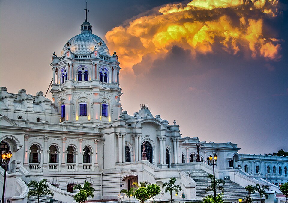
A historic royal palace in Agartala that reflects the architectural heritage of Tripura.
A remarkable water palace situated in the middle of Rudrasagar Lake.
A major Hindu pilgrimage destination located in Udaipur and associated with Shakti worship.
An archaeological and religious site famous for its remarkable rock-cut sculptures.
A scenic hill region known for its natural surroundings and panoramic views.
A protected natural area known for wildlife, forest habitats and bird diversity.
An archaeological destination associated with ancient Buddhist and Hindu remains.
A picturesque lake associated with Neermahal and an important natural attraction.
Transport and Connectivity
Tripura is connected with other parts of India through air, railway and road networks. These transport links are important for tourism, trade and the movement of residents.
Air Connectivity
Maharaja Bir Bikram Airport, located near Agartala, is the state’s principal airport. It connects the capital with several major Indian cities.
Railway Connectivity
Agartala is connected to the Indian railway network. Railway services link Tripura with destinations in Assam and other parts of the country.
Road Connectivity
National Highway 8 is an important road connection between Tripura and the rest of India. Roads also connect Agartala with towns and districts throughout the state.
Education and Literacy in Tripura
Education has played an important role in Tripura’s social development. The state has schools, colleges, technical institutions and universities serving students across different districts.
In June 2025, Tripura was declared a fully literate state after reporting a literacy rate of 95.6% under the ULLAS – New India Literacy Programme. The achievement followed sustained efforts to improve foundational literacy and numeracy among adults aged 15 years and above.
This milestone represents an important development in the state’s efforts to expand educational access and lifelong learning.
Frequently Asked Questions About Tripura
1. Where is Tripura located in India?
Tripura is located in Northeast India. It shares its borders with Bangladesh, Assam and Mizoram.
2. What is the capital of Tripura?
Agartala is the capital and largest city of Tripura.
3. When did Tripura become a state?
Tripura attained full statehood on 21 January 1972.
4. How many districts are there in Tripura?
Tripura has eight administrative districts.
5. What are the official languages of Tripura?
Bengali, English and Kokborok are the official languages of Tripura.
6. Which is the highest peak in Tripura?
Betling Shib in the Jampui Hills is the highest point in the state, at approximately 939 metres.
7. What is Tripura famous for?
Tripura is known for its royal heritage, indigenous cultures, bamboo and cane handicrafts, natural landscapes, wildlife and historic monuments.
8. What is the state fruit of Tripura?
Queen pineapple is the state fruit of Tripura.
9. What is the population of Tripura?
The state government’s projected population for 2025 was approximately 42.22 lakh. The last completed Census figure, from 2011, was 36,73,917.
10. Why is Tripura important in Northeast India?
Tripura has geographical, historical, cultural and economic importance because of its location along the Bangladesh border and its connections with other northeastern states.
Conclusion
Tripura represents an important part of India’s northeastern identity. Its historical royal legacy, indigenous communities, linguistic diversity, agricultural traditions and natural resources make it a distinctive state within the country.
From the heritage of Ujjayanta Palace and Neermahal to the ancient sculptures of Unakoti and the green landscapes of the Jampui Hills, Tripura offers a rich combination of history, culture and nature.
Its progress in education, infrastructure and economic development also forms an important part of the state’s contemporary story.
Information Sources and References
The following government and institutional resources can be consulted for official statistics and additional information about Tripura.
1. Government of Tripura
Official State Government Website
2. Tripura Information and Cultural Affairs Department
Official Information and Cultural Affairs Department
3. Press Information Bureau
Tripura’s Full Literacy Achievement – June 2025
4. Comptroller and Auditor General of India
Government Audit and State Statistics
Editorial note: Population projections, Census figures and literacy programme statistics refer to different reference periods and measurement methods. They should not be interpreted as directly interchangeable. Administrative and economic figures may change over time.
About The Author